Ich wollte nur einige Tests mit dem GPS mit einem ESP32 und NTRIP durchführen, aber ich konnte keine Firmware finden, die stabil genug wäre. Daher bleibt die Raspberry Pi-Lösung mit RTKBase, da dies wahrscheinlich die einfachste Testmöglichkeit ist – zumindest denke ich das, da ich in diesem Bereich keine Erfahrung habe.
Ich habe auch über diese App nachgedacht, um das GPS in Bewegung zu testen:
How to use Ardusimple products with SW Maps on Android smartphones/tablets
Ich habe auch über diese App nachgedacht, um das GPS in Bewegung zu testen:
How to use Ardusimple products with SW Maps on Android smartphones/tablets


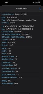


 , and as I said, centimeter-precise positioning isn't so important to me. In the Moment my RoπLawnMow runs ~ 0.3m/s. Faster is possible, but this is in the moment my best working speed for tests and degugging. If I use 1Hz, then I can always use the ODO metric data for the gaps between. and yes its my own Firmware based on python on a Pi3+